
Čez Visoke
Mojstrana – Dovje – sedlo Visoke – Plavški rovt – Jesenice - Mojstrana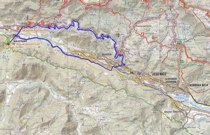
The trail starts from the car park in front of the Slovenian Alpine Museum. Turn right, towards Dovje (north) to Požgancev bridge over the river Sava Dolinka. After the bridge continue straight on (left is the road to Kranjska Gora) up the short but steep ascent to the main road.
Cross the main road and continue uphill to the village of Dovje. At the T-junction at the top of the hill (there is a shrine on the left and the old school on the right) turn right - 1.5km. Cycle through the village square and continue towards the new part of Dovje. At the next junction, turn left towards Dovška Baba - 1.8km. At the end of the houses the road becomes unmade. Follow it uphill to a junction where you bear right - 2.4km, 760m. After a brief gentle descent to the Mlinca hydroelectric power station, begin to climb steadily once again. Continue up to the next junction (approx. 4km) and on the left and right side there are several 'rovt', mountain pastures where cattle graze in the high season. The road leads past the mighty Blaščeva skala, a crag which is reminiscent of the famous Three Cine in the Dolomites. Towards the end of the first part of the ascent (approx. 1km before the junction) the road is relatively level. At the junction (Dovška Baba to the left), turn right to Visoki - 6.7km, 1080m. Then follows a 1.9km ascent to the saddle at Na Visokih - 8.6km, 1200m.
Next there is a descent towards Plavški Rovt. At Planina Zakamnik (mountain pasture) turn right to Plavški rovt - 11.5km, 1,025m. Continue down to the village of Plavški rovt where the tarmac road starts. At the end of the village is very short climb, followed by another descent to Jesenice.
At the traffic lights by the health centre (on your left), turn right towards Kranjska Gora - 16.6km, 570m. Continue along the main road for 500m, then turn left at the traffic lights just before a petrol station. Head downhill for about 40m and then turn left again. Make a short ascent over the bridge across the railway and continue to the next junction (with the company Doka on the right). Here turn left (17.6km), cross the bridge over the river Sava Dolinka and continue straight on through the underpass below the motorway to a junction with the cycle track. Here turn right and join the cycle track that leads to Mojstrana. The cycle track runs along the left side of the Karavanke tunnel, past Mlake and joins the main road that leads to Mojstrana just past a bridge over the river Sava - 24.4km. Turn left and follow the road past the ski slope and enter Mojstrana. Cross the bridge over the river Triglav Bistrica (just before the bridge on the right is the Tourist Office). At the junction turn left towards the Vrata, and after 500m you come back to the starting point - 26.5km.
WARNING: The climb to the saddle to high is long and hard.
Length: 26.5km
Total time: 3-5h
Difficulty of route: Very difficult
Starting point: Slovenian Alpine Museum, 650m. Coordinates WGS 84: N: 46°27'28''; E: 13°56'9''
Highest point: Na Visokih 1,200m.
Midpoint 1: Junction to Dovška Baba or Na Visoki 1080m. Coordinates WGS 84: N: 46°28'04''; E: 13°59'31''
Midpoint 2: Plavški Rovt: Coordinates: WGS-84: N: 46°17'12'' E: 14°02'02''
Final point: Slovenian Alpine Museum.
Height difference: 600m


