
Dovška Baba
Dovje – Goreljše – Planina Dovška Rožca – Dovška Baba – Mlinca Saddle – Brvog – Tromostovje – Dovje (marked path)
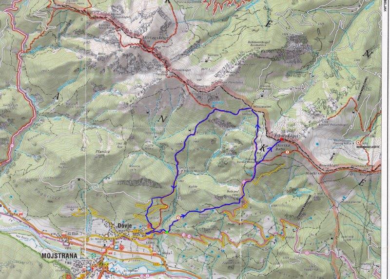
This path starts from the parking place a few metres from a small hydroelectric power station on the river Mlinca. The power station is near a weekend house along the unmade road to Ravne, 800m east of the village of Dovje. Cross the river, and you will see a sign for Dovška Baba pointing to a steep path into the woods. It first crosses two pastures ('rovt') bearing left. After an hour's walk you reach a bigger pasture, Goreljše, at a height of 1200m. Walk up the left hand side of the pasture to the top, and cross a fence and a cart track. The narrow path continues on the opposite side of the cart track, a few metres to the left. It leads up through the woods, marked by Via Alpina signs from here onwards. The path takes you under the walls of Bela Peč at 1459m. Continue until you reach the forest road at the Lah Saddle (1370m), where the path joins the forest road which leads to Planina (mountain pasture) Dovška Rožca. Follow the road for about 100m and then leave it for a marked path which takes you into the wood on your left. This is a steep path to Dovška Baba across Starka. Cross a fence at a brook and continue across a smaller pasture. Turn left at the end of this pasture and follow the steep path to a small saddle. Continue through the wood to Planina Dovška Rožca at 1650m - 2.30h. There is a herders' hut at the planina, open from mid-June to mid-September. From the hut continue up the the left side of the grassy edge until you reach the top of Dovška Baba (1893m - 3.15h).
To descend, go back the same way but 70m above the hut take a right turn onto a marked path. This path leads through the dwarf pine to the Mlinca Saddle at 1581m. From the saddle, the path ascends slightly, following direction signs to Kepa and winding under Plevelnica until it brings you to a junction to Kepa by a water trough (rack). From this point follow signs for Dovje and descend to the pasture Brvog which has a hunters' lodge at 1480m - 1h. From Brvog, the path takes you down towards the south, and is quite steep until you reach Tromostovje at 1065m - 1h. At Tromostovje two brooks, the Mlinca and the Žakelj, meet and join.
Follow the forest road for about 800m to a junction with another road. Turn left in the direction of Dovje. About 80m along the road there is a path to the right, a shortcut which crosses the road several times all the way down. Cross the last pasture with a transmitter at the bottom and rejoin the forest road below the transmitter. Follow this road to a T-junction, turn left and continue to the power station at Mlinca by the parking place (720m - 0.45h).
WARNING: Cattle graze all over Planina Dovška Rožca from mid-June to mid-September. Beware of the angry bull which might be there!
Total ascent: 2.5 - 4h
Ascent and descent: 7h
Difficulty: Demanding.
Equipment: Good walking shoes and physical condition are recommended.
Start: Parking place at the small hydroelectric power station at Mlinca, 800m from Dovje in the direction of Ravne - at 720m. Start coordinates: N:46°28'08''; E:13°57'38''
Intermediate point: Planina Dovška Rožca, 1650m
Highest point: Dovška Baba, 1893m. Coordinates: N:46°29'15; E:13'59'37''
Height difference: 1173m
Ascent distance: 4200m
Total distance: 10,000m
Source: Map Kranjska Gora 1:30,000 published by LTO Kranjska Gora


