
Jerebikovec
Mojstrana - Jerebikovec – Mojstrana (partly marked path)
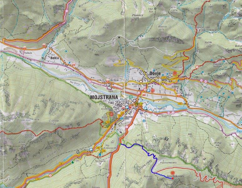
This path starts at a parking place by the Mojstrana - Zgornja Radovna road, at the top of a long rise of the road (the top of the first rise in the road after the turn-off to the tennis courts), about 1km from Mojstrana
towards Zgornja Radovna. There is room for about 5 cars by the road on the right-hand side.
On the opposite side of the road is a direction sign for Jerebikovec and Tilčev rovt (Tilč pasture). The path is wide and climbs steeply. After about 10 minutes you reach a rest point at Macesnovec where you can admire a beautiful view of the village of Dovje and the summit of Kepa. Continue the steep ascent up the path. In the upper section the path begins to make cris crosses ? hairpins which eases the gradient. About 45min from the rest point you reach the old planina Mežakla (mountain pasture no longer in use. The upper part is named Tilčev rovt. There is a partisan memorial from WWII. Head west and you soon reach a forest road in poor condition, which also marks the end of Tilčev rovt. This pasture can only be clearly seen looking down from the top because it has quickly become overgrown.
Cross the forest road and follow the direction sign for Jerebikovec, up the slope ahead. You soon reach a wooded ridge; follow ths ridge to the top of Jerebikovec. There is a meadow and a bivouac in a poor state of repair on your left; there is also a visitors' book. Enjoy the breathtaking views of the Krma and Kot valleys and Triglav with its surrounding mountains, and in the opposite direction, the Karavanke.
Descend the same way.
WARNING: The path is partly marked by direction signs but is not waymarked. Descending in wet conditions could be slippery.
Total ascent: 1.5-2h
Ascent and descent: 2-3.5h
Difficulty: Not demanding.
Equipment: Good walking shoes and physical condition are recommended.
Start: Parking place at the top of the first rise in the road: 730m. Coordinates: N:46°27'07''; E:13°56'09''
Intermediate point: Planina Mežakla, 1330m
Highest point: Jerebikovec, 1593m. Coordinates: N:46°26'34; E:13'57'20''
Altitude difference: 863m
Ascent distance: 2700m
Total distance: 5400m
Source: Map Triglav 1:25.000 published by Sidarta


