
Kepa
Tromostovje – Brvog – Gubno – Kepa –Gubno – Brvog – Tromostovje (marked path)
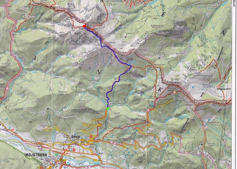
The parking place for this path is at Tromostovje (Three Bridges), the confluence of two streams, Mlinca and Žakelj. Three little bridges used to be here years ago and the place was named after the Ljubljana landmark, Tromostovje or Three Bridges. Turn left at Tromostovje and cross the Žakelj, following the wider path which continues on the other side of the stream for a few metres to a direction sign for Kepa on the fence, which directs you right and up. After a few minutes you will be above a weekend house on the pasture 'Erjavčev rovt'.
Continue along the marked path which heads steeply up through the woods. A little higher the path turns slightly to the right until you reach a quite level cart track. Follow it to a water trough, after which the path turns left and then comes out of the woods onto the 'planina' (grazing pasture) Brvog. Walk up across the grassy planina to reach a hunters' hut at 1470m, 1h.
From the hut, head right and walk north-east along the marked path into the woods. You will soon reach a partly grassy ridge, before the path leads to the right onto steeper slopes. A little higher the path becomes pleasantly level and takes you across the slopes with more and more views. Follow the marked path across a short landslide, taking care when crossing it. The level path brings you to a small spring, Koritec, with a junction marked to Kepa and to the saddle Mlinca, 30 min.
Turn left for Kepa. Ascending slightly, cross the slopes under Visoki Kurjek. Keep going up and across steep slopes towards the west until you reach a ridge with a view of the Austrian side. Continue along a rather narrow ridge first and then the path turns left, ascends again and crosses steep grassy slopes under the summit of Gubno at 2034m, 1h. Reach a gentle ridge on the south side of the summit where you get a view of Kepa ahead. The path becomes more demanding here as you cross an exposed section, a notch with steel cables and rungs for protection and aid. Along the ridge, the path takes you under the slopes of Dovška Mala Kepa at 2077m, 45 min. The path goes around the summit from the south side and then crosses a very steep rocky slope to reach the saddle between Kepa and Dovška Mala Kepa.
Continue west and cross steep slopes along the Austrian side of the ridge to a smaller saddle where a route joins the ridge from the Austrian side. The path gets steeper and continues along the ridge. The last part is not demanding as the path goes along grassy slopes with perfect views all the way to the summit of Kepa at 2139m.
To descend, use the same way.
WARNING: The notch before Dovška Mala Kepa is protected by steel cables, pegs and rungs.
Total ascent: 3,5-5h
Ascent and descent: 7.5h
Difficulty: Very demanding.
Equipment: Good walking boots and physical condition are recommended.
Start: The parking place for this path is at Tromostovje (Three Bridges), the confluence of two streams, Mlinca and Žakelj. Three little bridges used to be here years ago and the place was named after the Ljubljana landmark, Tromostovje or Three Bridges. Start coordinates: N:46°28'46''; E:13°57'48''
Intermediate point: Gubno, 2034m
Highest point: Kepa, 2139 m. Coordinates: N:46°30'24; E:13'57'09''
Altitude difference: 1074 m
Ascent distance: 4900m
Total distance: 9800m
Source: Map Kranjska Gora 1:30,000 published by LTO Kranjska Gora.


