
Vrtaško Sleme
Mojstrana – Vrtaška planina – Vrtaško Sleme – Vrtaški vrh – Vrtaška planina – Mojstrana (the first section is marked, but later it is unmarked). 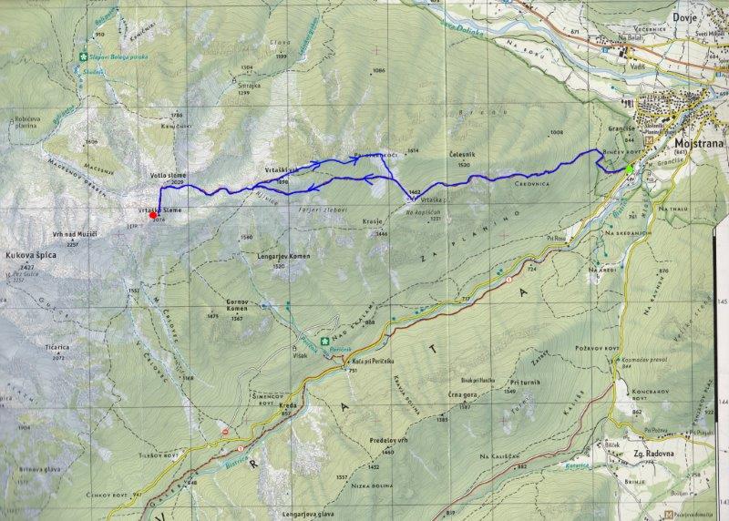
Start in Mojstrana at a parking place 300m past the Slovenian Alpine Museum in direction of the Vrata valley. The parking place is on the left immediately above the first steep slope on the road. A red direction sign for Sleme-Vrtaško Sleme is opposite the parking place.
The path starts ascending quickly and continues until you reach a rest point at Počivav. From here you have a beautiful view of the village of Mojstrana and its surroundings. The path is marked, wide and easy to follow. From Počivav, the steepness eases a little as the path starts to criss-cross the hillside. Further up it levels out and runs across grassy and rocky slopes to a “lesa” (pasture enclosure). This is a stop on a goods cableway. The path now ascends gradually through pleasant woodland all the way to Vrtaška planina (a grazing pasture) with its herders’ hut.
There is a beautiful view of Triglav and the surrounding summits at Vrtaška planina. To continue, head north and follow a small wooded valley to a direction sign for Sleme. Begin a long ascending traverse, heading north-west below Vrtaški vrh. When you reach a grassy ridge, walk along it, ascending a little, and reach the wood again. Keep traversing north-west until you reach the grassy plateau of Njivice. In the centre of the plateau there is a wooden water trough, and Vrtaški vrh is on the right. Climb to the top of the plateau and continue left towards Sleme. The path steepens in the last section before you reach a saddle between Sleme on the left and Votli Sleme on the right. At the saddle, head left; the highest point of Sleme is ahead of you, and Kukova Špica and other summits are behind it. There is a visitors' book at the top of Vrtaško Sleme.
The descent is by the same route. If you want to add the second highest point, head left at the top of the plateau of Njivice plateau towards Vrtaški vrh. If not, return along the same path to Vrtaška planina.
The path to Vrtaški vrh is not marked but it is easy to follow as cattle walk here. From Vrtaški vrh head east and follow a grassy ridge. The path is relatively clear, again because of the cattle, and it takes you to a small intermittent lake. Continue along the ridge and then descend slowly. When you get to the saddle a grassy valley opens below and in front of you to the south. Descend to the direction sign for Sleme which you passed while ascending. The path is marked from here to Vrtaška planina and to the parking place, your starting point.
WARNING: The path from Njivice across Vrtaški vrh is not marked but is easy to follow.
Total ascent: 3-5h
Ascent and descent: 5-8h
Difficulty: Demanding
Equipment: Good walking boots and physical condition are recommended.
Start: Parking place 300m from the Slovenian Alpine Museum towards the Vrata valley, altitude 660m. Coordinates: N:46°17'19''; E:13°55'55''
Intermediate point: Vrtaška planina,1462m
Highest point: Vrtaško Sleme: 2076m. Coordinates: N:46°27'06; E:13'52'18''
2nd highest point: Vrtaški vrh: 1898m
Altitude difference: 1416 m
Ascent distance: 500m
Total distance: 11000m
Source: Map Triglav 1:25.000 published by Sidarta


